
Longdo Map provider for the MapConductor React SDK. Renders a Longdo Map (Longdo Map API3, which uses MapLibre GL JS internally) through MapConductor's provider-independent camera, marker, and overlay API, so the same application code can also run on Google Maps, MapLibre, Mapbox, MapTiler, Leaflet, OpenLayers, ArcGIS, Cesium, HERE, or TomTom.
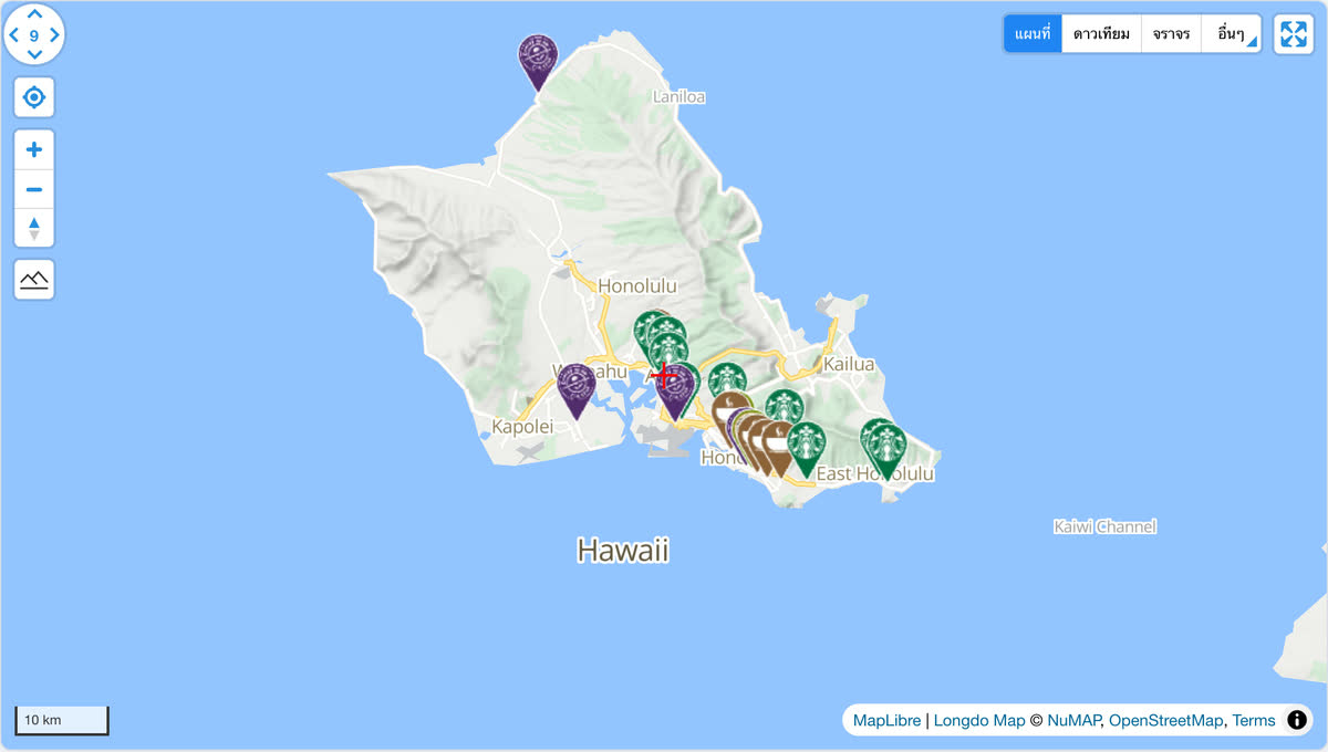
Open it in the live demo: the same store map runs on every provider, and the page switches between them. The code, cut down to three stores:
import { useMemo, useState } from 'react';
import {
  createGeoPoint,
  createMapCameraPosition,
  createMarkerState,
  type MarkerState,
} from '@mapconductor/js-sdk-core';
import { InfoBubble, Markers } from '@mapconductor/js-sdk-react';
import { LongdoDesign, LongdoMapView2D, useLongdoViewState } from '@mapconductor/react-for-longdo';

const STORES = [
  { id: 'waikiki', name: 'Waikiki', latitude: 21.2793, longitude: -157.8292 },
  { id: 'kailua', name: 'Kailua', latitude: 21.3972, longitude: -157.7394 },
  { id: 'haleiwa', name: 'Haleiwa', latitude: 21.5928, longitude: -158.1034 },
];

const INITIAL_CAMERA = createMapCameraPosition({
  position: createGeoPoint({ latitude: 21.38, longitude: -157.93 }),
  zoom: 10,
});

export default function App() {
  const mapViewState = useLongdoViewState({
    apiKey: 'YOUR_LONGDO_API_KEY',
    mapDesignType: LongdoDesign.Normal,
    cameraPosition: INITIAL_CAMERA,
  });
  const [selected, setSelected] = useState<MarkerState | null>(null);
  const markers = useMemo(
    () =>
      STORES.map(store =>
        createMarkerState({
          id: store.id,
          position: createGeoPoint({ latitude: store.latitude, longitude: store.longitude }),
          extra: store,
          onClick: marker => setSelected(marker),
        }),
      ),
    [],
  );

  return (
    <div style={{ width: '100%', height: '100vh' }}>
      <LongdoMapView2D state={mapViewState} onMapClick={() => setSelected(null)}>
        <Markers states={markers} />
        {selected && (
          <InfoBubble marker={selected}>
            <strong>{(selected.extra as (typeof STORES)[number]).name}</strong>
          </InfoBubble>
        )}
      </LongdoMapView2D>
    </div>
  );
}
Replace YOUR_LONGDO_API_KEY with your own key.
npm install @mapconductor/react-for-longdo @mapconductor/js-sdk-core @mapconductor/js-sdk-reactThe Longdo Map API3 script (which bundles MapLibre GL JS and its Web Worker) is
loaded from api.longdo.com on demand — you do not need to install or
configure maplibre-gl yourself, and there is no stylesheet to import.
Longdo Map requires a Longdo Map API key that is authorized for the web origin your app is served from (unlike the Android key, which is restricted by package name). Pass it to the view state:
const state = useLongdoViewState({
  apiKey: LONGDO,
  mapDesignType: LongdoDesign.Normal,
  cameraPosition,
});import {
LongdoDesign,
LongdoMapView2D,
useLongdoViewState,
} from '@mapconductor/react-for-longdo';
import { MapCameraPosition, createGeoPoint } from '@mapconductor/js-sdk-core';
// Your own key. Read it from your environment however your build tool does
// it, and keep it out of source control.
const LONGDO = '…';
function Map() {
const state = useLongdoViewState({
apiKey: LONGDO,
mapDesignType: LongdoDesign.Normal,
cameraPosition: MapCameraPosition.create({
position: createGeoPoint({ latitude: 13.7563, longitude: 100.5018 }),
zoom: 11,
}),
});
return <LongdoMapView2D state={state} />;
}LongdoDesign exposes the standard base layers provided by longdo.Layers:
Normal, Easy, Pastel, PastelGray, Hard, Gray, Light, Night,
Dark, Political, Osm, Satellite (SPHERE_IMAGES), Hybrid
(SPHERE_HYBRID).
Switch design by updating the view state's mapDesignType.
Longdo Map API3 renders through an internal MapLibre GL JS map exposed as
map.Renderer. This provider bootstraps the base map, camera, and base-layer
designs through the Longdo wrapper (longdo.Map) and drives camera control,
map events, and all overlays (markers, polylines, polygons, circles, ground
images, raster layers) through map.Renderer — the same MapLibre-based renderer
architecture used by the other MapConductor MapLibre-family providers.
Apache-2.0