
English | 日本語 | Español (Latinoamérica)
ArcGIS Maps SDK for JavaScript provider for the MapConductor React SDK. Renders
an ArcGIS MapView (2D) or SceneView (3D) through MapConductor's
provider-independent camera, marker, and overlay API, so the same application
code can also run on Google Maps, MapLibre, Mapbox, Leaflet, OpenLayers,
Cesium, or HERE.
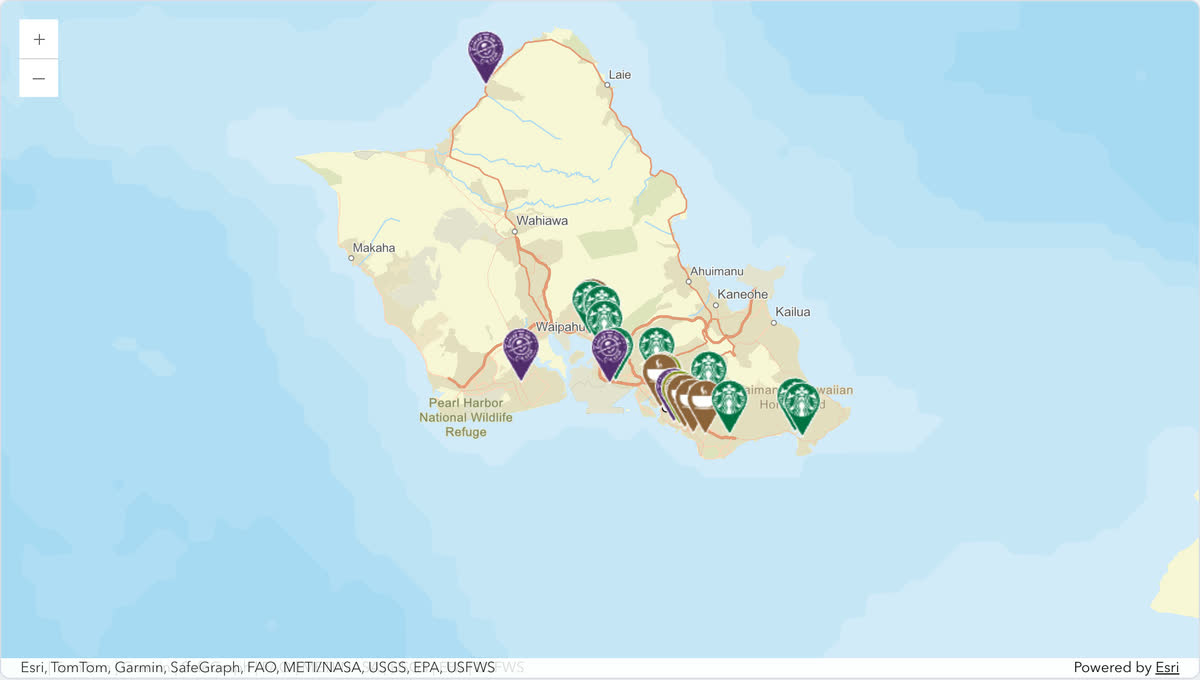
Open it in the live demo: the same store map runs on every provider, and the page switches between them. The code, cut down to three stores:
import { useMemo, useState } from 'react';
import {
  createGeoPoint,
  createMapCameraPosition,
  createMarkerState,
  type MarkerState,
} from '@mapconductor/js-sdk-core';
import { InfoBubble, Markers } from '@mapconductor/js-sdk-react';
import { ArcGISDesign, ArcGISMapView2D, useArcGISViewState } from '@mapconductor/react-for-arcgis';

const STORES = [
  { id: 'waikiki', name: 'Waikiki', latitude: 21.2793, longitude: -157.8292 },
  { id: 'kailua', name: 'Kailua', latitude: 21.3972, longitude: -157.7394 },
  { id: 'haleiwa', name: 'Haleiwa', latitude: 21.5928, longitude: -158.1034 },
];

const INITIAL_CAMERA = createMapCameraPosition({
  position: createGeoPoint({ latitude: 21.38, longitude: -157.93 }),
  zoom: 10,
});

export default function App() {
  const mapViewState = useArcGISViewState({
    apiKey: 'YOUR_ARCGIS_API_KEY',
    mapDesignType: ArcGISDesign.Streets,
    cameraPosition: INITIAL_CAMERA,
  });
  const [selected, setSelected] = useState<MarkerState | null>(null);
  const markers = useMemo(
    () =>
      STORES.map(store =>
        createMarkerState({
          id: store.id,
          position: createGeoPoint({ latitude: store.latitude, longitude: store.longitude }),
          extra: store,
          onClick: marker => setSelected(marker),
        }),
      ),
    [],
  );

  return (
    <div style={{ width: '100%', height: '100vh' }}>
      <ArcGISMapView2D state={mapViewState} onMapClick={() => setSelected(null)}>
        <Markers states={markers} />
        {selected && (
          <InfoBubble marker={selected}>
            <strong>{(selected.extra as (typeof STORES)[number]).name}</strong>
          </InfoBubble>
        )}
      </ArcGISMapView2D>
    </div>
  );
}
Replace YOUR_ARCGIS_API_KEY with your own key.
npm install @mapconductor/react-for-arcgis@mapconductor/js-sdk-core and @mapconductor/js-sdk-react (used for markers and
other shared components) are installed automatically as dependencies. Your
code imports from both directly, so with pnpm's strict (isolated)
node_modules — or whenever you prefer to declare everything you import —
install them explicitly instead:
npm install @mapconductor/react-for-arcgis @mapconductor/js-sdk-core @mapconductor/js-sdk-react@arcgis/core is bundled as a dependency. Esri basemaps require an API key
from the ArcGIS Location Platform; the
OSM-based designs work without one.
Pass the key to useArcGISViewState:
// Your own key. Read it from your environment however your build tool does
// it, and keep it out of source control.
const ARCGIS_API_KEY = '…';

const mapViewState = useArcGISViewState({
  apiKey: ARCGIS_API_KEY,
  mapDesignType: ArcGISDesign.Streets,
  cameraPosition: INITIAL_CAMERA,
});
Leave apiKey out and only the OSM-based designs will draw; the Esri ones
report ArcGIS API key is required.
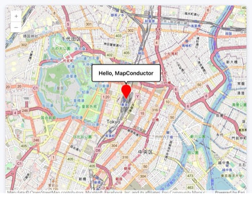
The simplest possible map app, built with MapConductor + ArcGIS: click the marker and a "Hello, MapConductor" bubble pops up. You can build it in the 5 steps below. It uses the OSM Standard basemap, which needs no API key, so you can copy-paste and it just works.
Create a React + TypeScript project with Vite.
npm create vite@latest hello-map -- --template react-ts
cd hello-map
npm install
npm run devInstall the package needed to show a map. We use ArcGIS here, but you can use other map modules too.
npm install @mapconductor/react-for-arcgis@mapconductor/react-for-arcgis— components / hooks for ArcGIS@mapconductor/js-sdk-react/@mapconductor/js-sdk-coreare installed automatically as dependencies.
Create the map state with useArcGISViewState and render it with
<ArcGISMapView2D>. Give the outer element a height to make it full-screen.
import {
  ArcGISDesign,
  ArcGISMapView2D,
  useArcGISViewState,
} from '@mapconductor/react-for-arcgis';
import { createGeoPoint, createMapCameraPosition } from '@mapconductor/js-sdk-core';

const TOKYO = createGeoPoint({ latitude: 35.6812, longitude: 139.7671 });
const INITIAL_CAMERA = createMapCameraPosition({ position: TOKYO, zoom: 14 });

export default function App() {
  const mapViewState = useArcGISViewState({
    mapDesignType: ArcGISDesign.OsmStandard,
    cameraPosition: INITIAL_CAMERA,
  });

  return (
    <div style={{ width: '100vw', height: '100vh' }}>
      <ArcGISMapView2D state={mapViewState} />
    </div>
  );
}
Use ArcGISMapView instead of ArcGISMapView2D to render a 3D SceneView
with the same camera semantics.
Create the marker state with createMarkerState and register it with
<Marker>. Write overlays as child elements of the map component.
import { useMemo } from 'react';
import { createMarkerState } from '@mapconductor/js-sdk-core';
import { Marker } from '@mapconductor/js-sdk-react';

// ...inside App...
const marker = useMemo(
  () => createMarkerState({ id: 'hello', position: TOKYO }),
  [],
);

// ...inside return...
<ArcGISMapView2D state={mapViewState}>
  <Marker state={marker} />
</ArcGISMapView2D>Track the selected state with useState, set it to true in the marker's
onClick, and render <InfoBubble> only while selected. This is the finished
app.
import { useMemo, useState } from 'react';
import {
  ArcGISDesign,
  ArcGISMapView2D,
  useArcGISViewState,
} from '@mapconductor/react-for-arcgis';
import {
  createGeoPoint,
  createMapCameraPosition,
  createMarkerState,
} from '@mapconductor/js-sdk-core';
import { InfoBubble, Marker } from '@mapconductor/js-sdk-react';

const TOKYO = createGeoPoint({ latitude: 35.6812, longitude: 139.7671 });
const INITIAL_CAMERA = createMapCameraPosition({ position: TOKYO, zoom: 14 });

export default function App() {
  const mapViewState = useArcGISViewState({
    mapDesignType: ArcGISDesign.OsmStandard,
    cameraPosition: INITIAL_CAMERA,
  });

  const [selected, setSelected] = useState(false);

  const marker = useMemo(
    () => createMarkerState({
      id: 'hello',
      position: TOKYO,
      onClick: () => setSelected(true),
    }),
    [],
  );

  return (
    <div style={{ width: '100vw', height: '100vh' }}>
      <ArcGISMapView2D state={mapViewState} onMapClick={() => setSelected(false)}>
        <Marker state={marker} />
        {selected && (
          <InfoBubble marker={marker}>
            <div style={{ padding: '8px 12px', fontWeight: 600 }}>
              Hello, MapConductor
            </div>
          </InfoBubble>
        )}
      </ArcGISMapView2D>
    </div>
  );
}- Coordinates, cameras and markers are created with
js-sdk-corefunctions (provider-independent). - The map component and hooks come from
react-for-arcgis(provider-specific). - Write overlays as child elements of the map component.
- Control show / hide with React
useState.
@mapconductor/js-sdk-core— geometry, camera, and state primitives@mapconductor/js-sdk-react— sharedMarker,Markers, shapes, and info bubbles